Editorial Feature
Wingtra and Delair sign on dotted line to offer practical business insights from large, high-accuracy drone mapping projects
Words By: Drone Major
The vertical take-off and landing (VTOL) WingtraOne mapping drone and delair.ai artificial intelligence (AI)-powered software will now be promoted in both companies’ portfolios of solutions for extracting useful business insights from large, high-accuracy drone mapping projects.
Earlier this year, Wingtra and Delair announced that the compatibility of the two products was tested and evaluated. Due to the complementarity of their solutions, they recently made the decision to join forces in a sales partnership.
“We tested WingtraOne data compatibility with delair.ai a while ago and were convinced by the ease of use and the functionality of the software, especially in cases where deep AI analytics and accessibility by stakeholders is important,” said Leopold Flechsenberger, Head of Sales at Wingtra.
The partnership enables both Wingtra and Delair to meet the exact needs of their clients. Delair can now offer a VTOL solution for clients whose projects require a completely vertical take-off and landing. At the same time, Wingtra’s customers benefit from the robust delair.ai data analysis toolkit and functionality enabling rapid processing of datasets into useful metrics and more efficient team collaboration around visual data.

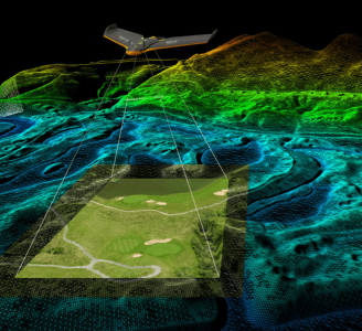
Delair.ai brings practical business tools to a range of drone mapping outputs, including multispectral, where users can monitor crops over time with powerful analytics from AI.
“The VTOL design of the WingtraOne drone is a great addition to the delair.ai ecosystem of partners. We are happy to offer even more choices to collect and analyze the huge amount of data generated by their activities to our customers, and enable them to transform it into immediate business decisions,” said Stefanie David, Partner Marketing Manager at Delair.
The delair.ai and WingtraOne bundle aims to simplify surveying operations in mining and aggregates; power and utilities; forestry, and agriculture industries. It will enable professionals to efficiently collect aerial data over large areas, analyze the gathered information and seamlessly share it across stakeholders.
About Wingtra
Founded in 2016 in Zurich, at the center of the Swiss drone valley, Wingtra has expanded globally with a distribution network in more than 50 countries where the drone is operated. Today, Wingtra houses more than 80 Wingtranauts committed to building the most reliable VTOL drone out there. Among Wingtra’s customers are Eberhard, Tetra Tech, Suncor Energy, and Dow Chemical.
About Delair
Delair is a leading provider of end-to-end visual intelligence solutions that enable enterprises to capture, manage and analyze their assets and turn the collected data into valuable business insights. The company’s offerings combine high performance UAV hardware with delair.ai, the industry’s most robust platform to power your entire visual intelligence workflow, from data management to advanced analytics. Its solutions are sold in over 70 countries with a network of more than 100 resellers in industries such as mining, construction, agriculture, oil and gas, utilities and transportation. Delair has strengthened its position as a global leader through strategic acquisitions (Gatewing, Airware/Redbird), and a strategic investment by Intel Corporation. Founded in 2011 by experts in the aerospace industry, the company employs 180 people and has offices in Toulouse, Paris, Los Angeles and Singapore. For more information, go to www.delair.aero.