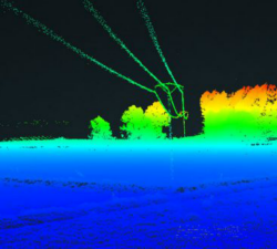
Skeye - UAV LiDAR
Price: CALL FOR ASSISTANCE
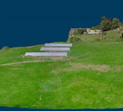
Skeye recently added a new sensor for recording geodata in addition to existing sensors such as daylight, near infrared and thermal cameras. The sensor is the YellowScan Surveyor which is capable of making very accurate and dense data points.
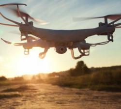
Digital Drone Services - Agricultural Services
Price: CALL FOR ASSISTANCE
Making life easier by performing agricultural surveys to increase yield or quality on crops, or for a number of other applications.
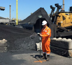
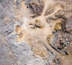
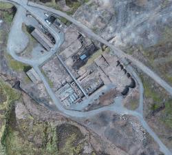
Skeye - Volume Computations
Price: CALL FOR ASSISTANCE
Skeye specializes in the accurate measurement of stocks or mountains stored material using unmanned helicopters (drones). These are equipped with a 36Mp digital camera and geometrically calibrated to perform measurements. These measurements are based on the photogrammetric principle whereby terrain heights can be calculated in the overlapping portion of photographs taken from another point of view.
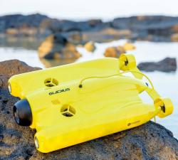
GeoAccess - Underwater Inspections
Price: CALL FOR ASSISTANCE
Once the preserve of traditional remotely operated vehicles (ROVs), GeoAccess can now offer underwater inspections, photography and video with our submersible drone, the Chasing-Innovation Gladius V2. We strongly believe that we can offer a cost-effective, comprehensive underwater inspection service, providing high-resolution photography and 4K video, without compromising quality and safety, and without having to rely on larger, cumbersome, less manoeuvrable ROVs.
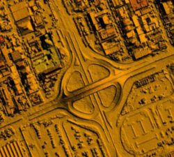
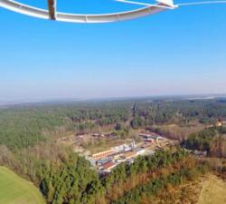
Skeye - Aerial Surveying & Mapping
Price: CALL FOR ASSISTANCE
Skeye uses drones (small unmanned helicopters and aircraft) to make aerial photographs at low altitude. With these pictures we make 3D digital height and terrain models and orthophoto mosaics (underlayers images).
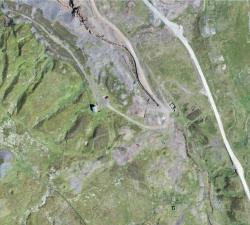
GeoAccess - Plant Health & Invasive Species Mapping
Price: CALL FOR ASSISTANCE
Aerial mapping can quickly and efficiently provide a means to assess the health and condition of a wide range of vegetation types and identify invasive species. The maps are a powerful tool for agronomists, farmers, growers and vegetation management teams to locate areas of concern quickly and allow ground-truthing to determine the problems and remedy the situation in much quicker time and make significant cost-savings.
Caelus Drones - Industrial Surveys
Price: CALL FOR ASSISTANCE
We can provide highly accurate data for surveys.
Digital Drone Services - Survey & Inspection
Price: CALL FOR ASSISTANCE
Any type of survey carried out from roof inspections to masts and towers.
Geo-4D - 3D Ground Modelling
Price: CALL FOR ASSISTANCE
Geo-4D offers full ground modelling capability and expertise combined with data QC and management services. We use the only software available that enables full interaction with all relevant site data, on dedicated work stations, avoiding the use of multiple software packages and awkward file exchange formats.
Digital Drone Services - Photogrammetry & Orthomosaics
Price: CALL FOR ASSISTANCE
Photogrammetry & Orthomosaic Services
Estate Drone Survey - Aerial Cinematography
Price: CALL FOR ASSISTANCE
Estate Drone Survey specialises in aerial cinematography using the latest unmanned aerial systems (UAS). As a fully licensed operator with permission from the Civil Aviation Authority, we are able to supply our clients with aerial filming and photography unsurpassed by any other provider. In order to operate a UAS commercially, you must be granted a permission for aerial work by the CAA. All of our operators have undertaken and achieved a BNUC-S qualification attained from the European Unmann
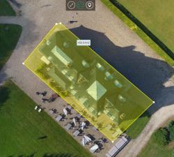
Geo-4D - Online Portal: Air Support by Parrot
Price: CALL FOR ASSISTANCE
Through our partnership with Parrot AS, Geo-4D can offer a fully interactive, online delivery platform for 2D and 3D drone data. Visualise 3D models of your buildings, 2D orthomosaics of your full site and add accurate measurements & calculate volumes, without the need to download specific software packages.
GeoAccess - Mapping & 3D Modelling
Price: CALL FOR ASSISTANCE
Our Principal Pilot has successfully completed a dedicated drone mapping course given by an ex-Royal Air Force aerial imaging and spatial analyst with 25 years of knowledge and experience in this highly specialist field. We can offer 2D mapping (ortho-mosaics) at various levels of resolution, with high relative accuracy and export the finished products in a variety of formats, depending upon client requirements. 3D models can be viewed in Sketch Fab and embedded directly in a webpage.
The Drone Guys - Photography and Video Filming
Price: CALL FOR ASSISTANCE
Being able to fly a drone doesn't make you a drone photographer .. Luckily The drone Guys are a group of highly skilled and professional photographers. Along with being skilled drone pilots they know exactly how to get that professional shot that is required by our clients. Using the most up to date equipment and post processing techniques to get you exactly what you need from the air.
Skeye - Digital Terrain Models
Price: CALL FOR ASSISTANCE
Skeye specializes in making aerial photographs at low altitude with a geometrically calibrated camera. This enables us to obtain all heights, of a landscaped area. At each height (Z) the coordinates (X, Y) are also recorded. This creates a digital terrain model that can be calculated quickly and accurately. The volume of a stockberg can be calculated relative to a base plane or if two measurements take place at different times, a difference calculation can be made.