Moonrock Insurance - Drone Insurance
Price: From £31 - £68
We pride ourselves on offering the best drone insurance in the UK that's suited perfectly to professional drone operators seeking superior insurance to operate drones commercially in the UK. Our staff are well informed on both insurance and the drone industry and will always ensure you have the correct policy for your needs.
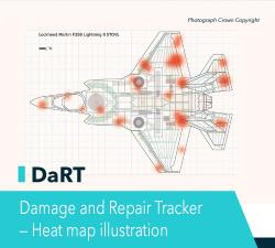
tlmNexus Ltd - DAMAGE AND REPAIR TRACKER (DaRT)
Price: CALL FOR ASSISTANCE
A popular consultancy and software solutionYour entire system’s damage and repair can be recorded and tracked in a single location by multiple users, with Damage and Repair Tracker (DaRT). This includes tracking work on the system’s associated removable parts, which may previously have been overlooked, due to the disparate nature in which damage and repairs were recorded.
Net Foundry - APIs & SDKs for private Internet overlay networks
Price: CALL FOR ASSISTANCE
Enable a new art of the possible by replacing VPNs, private circuits and custom hardware with code.Your application now controls the network. And not just any network. The global NetFoundry Fabric - the world's only security and performance optimized Internet overlay designed to be controlled by your application.
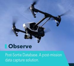
tlmNexus Ltd - OBSERVE
Price: CALL FOR ASSISTANCE
Tool overview: what will Observe -Post-Sortie Database solve for me?Designed by pilots for pilots, Observe -PSD was developed in specific partnership with DE&S to capture, manage and analyse key system performance management information
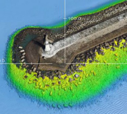
Skeye - Digital Terrain Models
Price: CALL FOR ASSISTANCE
Skeye specializes in making aerial photographs at low altitude with a geometrically calibrated camera. This enables us to obtain all heights, of a landscaped area. At each height (Z) the coordinates (X, Y) are also recorded. This creates a digital terrain model that can be calculated quickly and accurately. The volume of a stockberg can be calculated relative to a base plane or if two measurements take place at different times, a difference calculation can be made.
Dedrone - DroneTracker
Price: CALL FOR ASSISTANCE
Dedrone provides an automatic, integrated, and self-contained platform that delivers drone classification and countermeasures to secure against drone threats and their operators 24/7. DroneTracker is the only modular system on the market that can be customized to address site-specific threats, adapted for easy integration to an existing security program, and accommodates unique building structures, landscapes, and other exterior conditions.
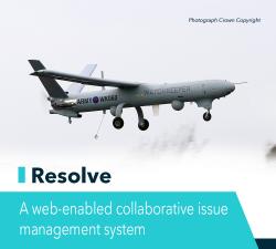
tlmNexus Ltd - RESOLVE
Price: CALL FOR ASSISTANCE
Tool overview: what will Resolve solve for me?Equipment issues that affect airworthiness, safety and through-life engineering can often be difficult to manage, especially when those issues are held across a range of platforms from local area databases to emails and hard copies.Such systems struggle to provide project teams with a cohesive picture of key issues and their actions, and also makes prioritisation difficult.We developed Resolve in partnership with Defence Equipment & Support (DE&S) to enable clear Ownership, Categorisation and Progression of issues across platform, cluster and inter-cluster domains promoting ‘Best Practice’ and complete management of all issues from initial recording through to resolution.
Geo-4D - Online Portal: Air Support by Parrot
Price: CALL FOR ASSISTANCE
Through our partnership with Parrot AS, Geo-4D can offer a fully interactive, online delivery platform for 2D and 3D drone data. Visualise 3D models of your buildings, 2D orthomosaics of your full site and add accurate measurements & calculate volumes, without the need to download specific software packages.
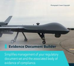
tlmNexus Ltd - EVIDENCE DOCUMENT BUILDER
Price: CALL FOR ASSISTANCE
Tool overview: what will Evidence Document Builder (EDB) solve for me? Complying with the continuously evolving requirements associated with a regulatory framework such as the UK MOD Military Aviation Authority’s Release To Service (RTS), is a complex undertaking. While you may be compliant today, the challenge is to maintain compliance to keep in line with equipment and platform configuration updates. Regular amendments to documents and the body of evidence forming the basis of your compliance argument are difficult to track and they can directly impact equipment and platform availability and safety. When configured to meet your required regulatory framework, EDB provides an audit trail of decisions and updates to your body of evidence going right back to the original requirement for the change. Furthermore, you can be confident that the confidentiality, integrity and availability of your information is maintained.

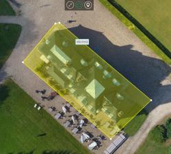
Scopito - Drone Inspection Software
Price: CALL FOR PRICE
Scopito is simple to use and can be accessed from many different types of devices. In the field or in the office you have the ability to analyze, visualize and apply tags or comments to your images from a variety of portable devices, as well as standard laptops and desktops.
Skeye - Volume Computations
Price: CALL FOR ASSISTANCE
Skeye specializes in the accurate measurement of stocks or mountains stored material using unmanned helicopters (drones). These are equipped with a 36Mp digital camera and geometrically calibrated to perform measurements. These measurements are based on the photogrammetric principle whereby terrain heights can be calculated in the overlapping portion of photographs taken from another point of view.
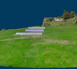
Geo-4D - 3D Ground Modelling
Price: CALL FOR ASSISTANCE
Geo-4D offers full ground modelling capability and expertise combined with data QC and management services. We use the only software available that enables full interaction with all relevant site data, on dedicated work stations, avoiding the use of multiple software packages and awkward file exchange formats.
Terabee - Intelligence for Drone Applications
Price: CALL FOR ASSISTANCE
Terabee welcomes collaboration from partners looking for innovation in sensing and intelligence for drone applications! Our technical expertise includes drone-optimized “indoor GPS” for GPS-denied environments, sensor fusion, algorithms, control system development, custom sensor design, sensor industrialization and integration into customer platforms.
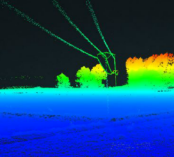
Skeye - UAV LiDAR
Price: CALL FOR ASSISTANCE
Skeye recently added a new sensor for recording geodata in addition to existing sensors such as daylight, near infrared and thermal cameras. The sensor is the YellowScan Surveyor which is capable of making very accurate and dense data points.